Information

Developed by the Educational Development Unit, University of the Highlands and Islands.
Disclaimer
UHI provides links to external sources of information and may refer to specific Web sites, products, processes or services within this resource. Such references are examples and are not endorsements and whilst every effort is taken to ensure the accuracy of information provided UHI is not responsible for any of the content or guidance. You are advised to exercise caution.
Information on social media websites may also be provided. Staff using social media websites must comply with the University’s social media policy. It is recommended that you fully understand the terms and conditions of use before using these sites and that you take steps to protect personal or sensitive data.
Using the map
Use the layer control at the top right to show/hide the map layers. Each location is identified on the map with these icons -


Hovering over a location will reveal its name. Left-clicking on a marker will display content relating to the location.
Map Controls
Using the map controls in the top left hand corner  or using the mouse scroll wheel will allow you to zoom in/out of the map for finer control and viewing of a locations geographical features.
When hovering over the map, your cursor will change to a hand icon. Holding down a left click will change the icon to a grab symbol allowing you to drag the map to the desired location.
To reset the map to its original state, refresh your browser by using the F5 key on your keyboard, or the refresh symbol in your browser.
Close these instructions using the X in the top corner to continue, you can locate these instructions in the icon at the top of this window.
The Falkirk Wheel
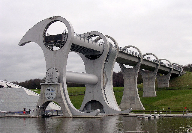
'The Falkirk Wheel' © Copyright Val Vannet and licensed for reuse under the Creative Commons Licence.
The Falkirk Wheel is a rotating boat lift, connecting the Forth and Clyde Canal with the Union Canal. Opened in 2002, it reconnects the two canals for the first time since the 1930s as part of the Millennium Link project.
The total budget for the Millennium Link was £84.5m, £32m of which came from lottery funds. By far the largest single element, £17.5m, was spent designing and building the wheel.
The wheel can carry eight or more boats at a time, and is 35m or 115ft high, the height of eight double-decker buses. Each gondola contains 300 tonnes of water, meaning that the wheel moves 600 tonnes on each lift, but because the gondolas are always in balance (because boats displace their own weight of water) moving them takes surprisingly little power.
Visitors can take an hour long boat trip ascending in the wheel up to the canal before descending once more. There is also a visitor centre with a café, a kids activity zone, canoe and bike hire, and a network of all ability walks.
×Scottish Sea Life Sanctuary

'Grey Seal in the water' © Copyright Mateusz Włodarczyk and licensed for reuse under the Creative Commons Licence.
On the shore of Loch Creran, the Scottish Sanctuary houses an aquarium as well as Scotland's leading Seal Hospital.
The aquarium contains a wide range of sea life that can be found beneath the lochs of the West Highlands or in the adjacent Atlantic, from shrimps and starfish to sharks and stingrays. It includes a stud farm for seahorses, and a turtle sanctuary.
The Seal Sanctuary is the focus for abandoned seal pups on the West Coast of Scotland as well as taking the occasional seal from the East and North Coast. Each year 12-15 pups are handed into the sanctuary, all of which are reared and released back into the wild, with minimum handling from staff, leaving the adult seals to develop and breed in their own specialised environment.
There is also a gift shop, coffee shop, and forest play area.
×Staffa, Fingal's Cave

'Fingal's Cave, with basalt column visible at mouth' © Copyright Colin Smith and licensed for reuse under the Creative Commons Licence.
Staffa is an unspoilt and uninhabited island known for its basalt columns and sea caves. The most famous of these is Fingal’s cave. The cave's size and naturally arched roof, and the sounds produced by the echoes of waves, give it the atmosphere of a natural cathedral. The cave's Gaelic name, An Uaimh Bhinn, means "the melodious cave."
Staffa has been a source of inspiration for visiting artists over the centuries. Famous visitors have included Queen Victoria and Prince Albert, the artist J M W Turner, and poets and writers Keats, Wordsworth, Tennyson and Sir Walter Scott. It was also inspiration for Felix Mendelssohn’s 1830 Hebridean Overture, (Fingal’s Cave).
- Fingal's Cave featured in the 1971 film When Eight Bells Toll.
- Modern day tourists visit by boat trip from Tobermory and Oban.
- Staffa is owned by the National Trust for Scotland and was declared a National Nature Reserve in September 2001 by Scottish Natural Heritage.
Smoo Cave

'Smoo Cave' © Copyright Florian Fuchs and licensed for reuse under the Creative Commons Licence.
The cave is set into the limestone cliffs in Sutherland. Smoo cave boasts the largest entrances to any sea cave in Britain, at 50 ft high. It was formed by a burn that runs down into the rear chamber, as well as erosion caused by the sea.
The cave is flood lit inside, and is presently served by a car park, toilets, stairs and walkways. Plans are being considered for access improvements for the estimated 40,000 visitors it receives annually. Tours of the cave also operate during summer months, taking visitors to the inner chamber by boat.
Archaeological investigations have found Neolithic, Norse and Iron Age artifacts, and it is thought that usage may extend back to the Mesolithic age. The cave name originates from the Norse 'smjugg' or 'smuga' meaning a hole or hiding-place.
×Scottish Seabird Centre/ National Marine Centre
The Scottish Seabird Centre is an education and conservation charity. The award winning centre provides educational interpretation of the seabird population of the Firth of Forth. There are live cameras on various islands, which can be remotely controlled by visitors. There is also a Wildlife Theatre, Scope Deck, Flyway Tunnel and a Turtle and Ray Zone. There is a Kids' Zone where little ones can go wild and Kids' Corner for quieter playtime.
The charity are currently undertaking a new project to create a National Marine Centre. The main purpose of the project is to expand the education and conservation work of the charity. The aim is to build on existing activities and share more widely the importance, value and issues affecting Scotland’s unique and fascinating marine environment and wildlife, including seabirds.

'Scottish Seabird Centre, North Berwick' © Copyright Richard West, licensed for reuse under the Creative Commons License

'Northern Gannet' © © Copyright Andreas Trepte and licensed for reuse under the Creative Commons Licence.
The project involves the development of new education and conservation programmes, exhibitions and facilities. An extra storey will be added to the existing building to accommodate this.
×HMS Victory/ Mary Rose
Portsmouth has a long naval history, housing Lord Nelson’s HMS Victory and King Henry XIII’s Mary Rose. HMS Victory was launched in 1775, and in the years to come, over an unusually long service, she would gain renown leading fleets in the American War of Independence, the French Revolutionary War and the Napoleonic War. In 1805 she achieved lasting fame as the flagship of Vice-Admiral Nelson in Britain's greatest naval victory, the defeat of the French and Spanish at the Battle of Trafalgar. She is now fully restored, and visitors can tour her decks.

'The HMS Victory, docked in Portsmouth, and open as an interperative visitor attraction' © Copyright David Hewitt and licensed for reuse under this Creative Commons Licence.

'The remains of the Mary Rose's hull' © Copyright Mary Rose Trust and licensed for reuse under the Creative Commons Licence.
The Mary Rose is a Tudor ship, built in 1510. She was in service for 34 years, before sinking in 1545 surrounded by mystery. No one knows for sure why she sank. She was not discovered until 1971. In 1982, in a complicated procedure, she was raised from the sea bed mostly intact. Now in the final stages of conservation, she takes her place in a stunning and unique museum. After centuries under water, the wreck must be constantly sprayed with sea water, to prevent rapid deterioration.
×Surf Snowdonia
Contribution by: Angus Jenkins
Surf Snowdonia have created the world’s first inland artificial fresh water wave garden, the “size of six football pitches” (Surf Snowdonia, 2015). The lagoon opened in summer of 2015 in North Wales, in the lee of the Snowdonia Mountains.
It has been described as “clean, fresh, wild and beautiful” (Surf Snowdonia, 2015). The wave machine creates a perfect 2m wave which can be ridden for 150m. Spectators can watch the action in the wave garden from the 50m glass fronted viewing gallery, which allows “your friends and the whole family to enjoy” (Surf Snowdonia, 2015).

'Riding the wave at Surf Snowdonia, 2 days after opening' © Copyright DeFacto and licensed for reuse under Creative Commons Licence

'Overview of the wave pool and surrounding buildings, Surf Snowdonia' © Copyright DeFacto and licensed for reuse under Creative Commons Licence
Surf Snowdonia was built on an old industrial site which was considered an eyesore. The wave garden makes great use of the land, whilst clearing the site of industrial waste, and bringing revenue and tourism into the local economy.
Surf Snowdonia are promising more fun with current development of a “Crash and Splash Lagoon”, an assault course billed as “your opportunity to push your agility, balance and determination to the limits… and you’d better prepare yourself for some spectacular splashdowns!” (Surf Snowdonia, 2015). It will consist of giant spinning balls, monkey bars, climbing bars, balance beams and rope bridges. There is also a café, pod accommodation, a soft play, and retail outlets.
×Sellafield
Sellafield was site of the world’s first commercial nuclear power station, Calder Hall, operating from the early 1950s until 2004. It has always been surrounded in controversy, especially since one of the piles caught fire in 1957, spreading radioactive contamination across the Lake District.
At its peak, the Sellafield Visitors' Centre attracted an average of 1,000 people per day. Its aim was to ‘to provoke debate among all visitors about how we should provide power for people in the 21st century.’ In recent years, its popularity deteriorated, prompting the change from tourist attraction to conference facility. The site itself is now a nuclear fuel reprocessing and decommissioning site.

'Aerial view, Sellafield, Cumbria' © Copyright Simon Ledingham and licensed for reuse under this Creative Commons Licence
The Visitors Centre is completely closed, and there are no areas for the public to visit. The beach is regularly monitored for levels of radioactivity, though this should not affect public use of the beach. However, the Cumbrians Opposed to a Radioactive Environment (CORE) pressure group wants notices to be displayed advising visitors that radioactive particles have been detected in the area. Sellafield said there had never been a "single incident" of contamination. CORE said a survey of beach users found 97% felt they had a right to be informed of the issue.
×The Kelpies
Contribution by Ruby Howard

The Kelpies / CC BY-SA 4.0
The Kelpies, opened in April 2013, are each made of 300 tonnes of steel, and stretch almost 30m high. They are placed at the new Helix development, which connects various communities, and both the Forth and Clyde canals. They can be seen from The M9, and have quickly become an icon of Scotland. Visitors can take a guided tour, and go inside the structures
The sculptor, Andy Scott, started with the idea of the mythical shape shifting creatures that live in the sea and lochs of Scotland, which were thought to appear as a horse, or as a beautiful human. This was used as a metaphor for the transformation of the area. The strong equine theme also came to represent the heritage of heavy industry, and the canals.
Two sets of 1:10 maquettes have been on display around Scotland, and in the USA.
×Clyde Estuary
The Firth of Clyde encloses the largest and deepest coastal waters in the British Isles, sheltered from the Atlantic Ocean by the Kintyre peninsula. The firth encompasses many islands and peninsulas and has twelve ferry routes connecting them to the mainland and each other. A great number of sea lochs adjoin the firth, the largest being Loch Fyne.
The Clyde formed an important sea route from the earliest times, and the Battle of Largs in 1263 marked the turning point for the end of Viking ambitions in Britain. From the 16th century onwards the Clyde became the conduit for commerce and industry, including herring, timber, wine, sugar, tobacco, textiles, iron and steel, coal, oil, chemicals, distilling and brewing, ships, locomotives, vehicles and other manufactured products. During World War II Glasgow and the Clyde became Britain's main entry point for Allied shipping.
The River Clyde has been a centre for shipbuilding for hundreds of years, possibly since as early as the 15th century. The industry went into massive decline in the 1960s and 70s. However, since 2001 the Clyde Yards, operated by BAE Systems, have seen a massive resurgence and now employ almost 4000 people.
With the advent of tourism in Victorian times, the area became popular with Glaswegians and neighbouring residents who travelled 'doon the watter' on Clyde steamers to holiday in the picturesque seaside towns that line the firth. The wealthy built holiday homes along its coasts. The area has been a major centre for recreational boating for well over a century. It is increasingly popular as a destination for sailors cruising in their own yachts, and for those seeking a charter yacht holiday, or courses in sailing.

'HMS Ambush Arriving at HMNB Clyde' © Copyright Stu Hill and licensed for reuse under the Creative Commons Licence.

'PS Waverley passing Port Glasgow.' Built on the Clyde in 1946, and the last sea-going paddle steamer in the world © Copyright Matt Kieffer and licensed for reuse under the Creative Commons License
In more recent times the natural beauty of the firth has been compromised by industrial and military developments along the shoreline. The firth is controversially home to Britain’s nuclear weapons, the Trident submarine missiles.
The Clyde has ten large marinas with capacity for several thousand boats, a host of marine services to offer, a wonderfully scenic cruising area, and many destinations, ranging from sheltered bays to busy fishing harbours. The availability and lower cost of berthing make keeping a boat here attractive, when compared with England’s South Coast
A regular riverbus service is now links Glasgow city centre and key visitor attractions during the summer months.
×Cape Wrath

'Cape Wrath from the sea, showing the sea cliffs and lighthouse' © Copyright Colin Wheatley and licensed for reuse under the Creative Commons Licence.
Cape Wrath is the most North-Westerly point on mainland Britain. The name derives from the Norse for "Turning Point", highlighting its significance 1,000s of years ago to Viking explorers from Scandinavia. For modern day sailors or sea kayakers navigating the Scottish coast it is still a significant landmark, and an area of big seas and few safe landings.
It was once a populated community, but is now uninhabited. Much of the Cape is owned by the Ministry of Defence and is used as a military training area, including as live firing range. Areas of it are also designated as a Site of Special Scientific Interest, a Special Protection Area, a Special Area of Conservation and a Special Landscape Area.
The Kyle of Durness separates the Cape from the mainland. A road was built in 1828 running 11 miles out to the lighthouse. From here it is possible to see both the Orkneys and the Western Isles.
The road is accessed via a passenger ferry, running seasonally from Easter until Oct. There is a café at the lighthouse, and during the summer months a minibus service to shuttle visitors between the ferry and here.
×Moray Firth

'Adult female Bottlenose Dolphin with two young at side, Inner Moray Firth' © Copyright Peter Asprey and licensed for reuse under the GNU Free Documentation License
The Moray Firth is one of the most important places on the British coast for observing dolphins and whales
It is estimated that around 130 bottlenose dolphins live in the Moray Firth. The dolphins often leap clear of the water close to the shore. Harbour seals are also a common sight, hauled out on mudbanks and sandy shores. Further out, harbour porpoises, white-beaked dolphins, minke whales, pilot whales and killer whales can sometimes be seen.
As well as several boat-tour operators, there is a popular wildlife viewing area at Chanonry Point. Also there are visitor centres at Spey Bay and North Kessock, run by the Whale and Dolphin Conservation Society where dolphins and other wildlife can often be seen. The old jetty at the Fort George Point is the location of the Dolphin Research Centre.
The Inner Moray Firth is designated as a Special Protection Area for wildlife conservation purposes. The Moray Firth contains a Special Area of Conservation (SAC) designated under the EU Habitats Directive, which is one of the largest Marine Protection Areas in Europe.
×Firth of Forth/ Edinburgh

'The Forth Rail Bridge, late at night' © Copyright George Gastin, licensed for reuse under the Creative Commons License
The Firth of Forth spans from Edinburgh and the Lothian Coast, across to Fife. The rail bridge, built between 1882 and 1890, is world renown. Finally, a non-corroding paint has been developed, which means the ceaseless task of repainting can finally take a 25 years break. The road bridge, opened in 1964, links Edinburgh to the North. Under a Labour government, a controversial toll was imposed. The booths were dismantled when the SNP came into power in 2008. An additional road bridge to deal with the traffic bottle neck is currently under construction.
The firth sees frequent visits from large cruise liners. It contains many islands with historical and wildlife interest. Some were manned during WWII, and concrete bunkers remain.
×The Wash
The Wash is the square-mouthed bay and estuary. Owing to deposits of sediment and land reclamation, the coastline of the Wash has altered markedly within historical times; several towns once on the coast of the Wash (notably King's Lynn) are now some distance inland. Much of the Wash itself is very shallow, with several large sandbanks exposed at low tide. For this reason, navigation in the Wash can be hazardous for boats. There is also a tidal node just outside The Wash, where flood tides from two directions meet, causing further navigational issues.
The Wash is a Special Protection Area (SPA). It is made up of very extensive salt marshes, major intertidal banks of sand and mud, shallow waters and deep channels. The seawall at Freiston has been breached in three places to increase the saltmarsh area, to provide an extra habitat for birds, particularly waders, and also as a natural flood prevention measure. The extensive creeks in the salt marsh, and the vegetation that grows there, helps dissipate wave energy thus improving the protection afforded to land behind the saltmarsh.

'The Wash, Heacham beach' © by Southgeist and licensed for reuse under the Creative Commons Licence.

'The Snettisham Jetty in the RSPB Bird Reserve' Image is in the public domain
This is an example of the recently developing exploration of the possibilities of sustainable coastal management by adopting soft engineering techniques, which are the use of ecological principles and practices to reduce erosion, and achieve the stabilisation and safety of shorelines and the area surrounding rivers, while enhancing habitat, improving aesthetics, and saving money.
×Norfolk Broads
The Broads are a network of mostly navigable rivers and lakes in the English counties of Norfolk and Suffolk which attract 7 million visitors a year. The lakes, known locally as broads, are not a natural landscape, but a result of intensive digging of peat in the Middle Ages to provide fuels. The Broads has similar status to the national parks in England and Wales under its own legislation, The Broads Authority Act 2009. The protected wetland is home to a wealth of wildlife, especially birdlife.
In 2010, after a period of decline, the Norfolk Broads Forum rebranded the area as ‘Britain’s Magical Waterland’. Ian Russell, chairman of the forum stated: 'The Broads brand needs looking after. The destination did not re-invest in itself and people just assumed visitors would keep coming. But now it is being eclipsed by other boating destinations in Scotland, France and Holland'. The world’s first commercially operated solar boat, Ra, is part of the image rebranding.

'St Benet's Abbey, from the River Bure' © Copyright Richard Harvey and licensed for reuse under the Creative Commons Licence.

'Sailing boats, Norfolk Broads' from Pixabay, image is in the public domain
Tourist activities include boating holidays, sailing, canoeing, kayaking, windsurfing, walking, fishing and cycling. The Norfolk Broads has many hotels, B&B, country cottages, parks and camping sites.
×Thames
The River Thames has played several roles in human history: as an economic resource, a maritime route, a boundary, a fresh water source, a source of food and more recently a leisure facility. The river slowed the Roman advance through Britain over two millenia ago, and has been used as a strategic stronghold since.
The 16th and 17th centuries saw the City of London grow with the expansion of world trade, and the Thames was Britain’s gateway between the Capital and the world’s sea ports. It also brought goods such as timber, wool, foodstuffs and livestock, and Cotswold stone used to build St. Paul’s Cathedral, from inland.
The Thames in London famously froze over in 1607, for the first ‘Frost Fair’. A tent city was set up on the river, along with a number of amusements, including ice bowling.

'A multi segment panoramic image of the London skyline from the Bermondsey banks of the Thames' © Copyright Diliff and licensed for reuse under theGNU Free Documentation License

'The Thames Barrier' © Copyright Peter Trimming and licensed for reuse under the Creative Commons Licence.
By Victorian times, the amount of raw sewage going directly into the river was a major issue, with a number of serious cholera outbreaks. In the ‘Great Stink' of 1858, pollution in the river reached such an extreme that sittings of the House of Commons at Westminster had to be abandoned.
In 2006 British swimmer and environmental campaigner Lewis Pugh became the first person to swim the full length of the Thames, in 21 days. The Thames remains an important access to the sea, whilst also accommodating sailors, kayakers and rowers. There are many tourist boat trips that take in sites such as the Tower of London, Tower Bridge, and the Houses of Parliament.
The river is tidal up to Teddington Lock, on the east side of the City of London, but inside the M25. The Thames Barrier is located downstream of central London. Operational since 1982, its purpose is to prevent the floodplain of all but the easternmost boroughs of Greater London from being flooded by exceptionally high tides and storm surges moving up from the North Sea
×

Channel Islands
The Channel Islands are an archipelago of British Crown Dependencies. The islands’ rich heritage includes much French influence, yet each has their own distinct flavour. English is the official language, French is used for administration, and there are several varieties of Norman language used by a minority of the population.
Tourism is the major industry in the smaller islands (with some agriculture). However Jersey and Guernsey have, since the 1960s, become major offshore financial centres. Lonely Planet describe the islands as “overflow(ing) with exquisite coastlines, beautiful harbours, shaded lanes and old-world charm. The warm Gulf of St Malo ensures subtropical plants, superb local seafood and an incredible array of bird life”.

'World War II fortified observation tower at Les Landes, Jersey' © This work has been released into the public domain by its author, Man vyi

'Walking out to St Helier Hermitage at low tide' This work has been released into the public domain by its author, Man vyi.
There are three airports in the Channel Islands; Alderney Airport, Guernsey Airport and Jersey Airport, which are directly connected to each other. Ferries reach the island from both England and France.
×Land's End
Contribution by: Fiona Christian
Land's End also is the most westerly point of mainland England, not to be confused with the Lizard Point, which is the most southerly point of mainland UK. Land's End is a granite headland standing around 65m high, and overlooking Sennen Cove and Pordenack to the south. It is iconic for representing the start or end point of the longest possible straight line journey in the British Isles, the other end being John O’Groats, 838 miles away.
A visitor centre with shop, cafe and attractions is open in the summer months. You can experience the rugged beauty of the windswept headland, and also learn about the history of life of the area with exhibitions, quests and galleries, and even hear a stories of sea rescues, or the legend of the lost Celtic city of Lyonesse.

'Longship's Lighthouse, originally built in 1795, as seen from landward' © Copyright vijay02 and licensed for reuse under theGNU Free Documentation License

'The granite coast at Land's End, the most westerly point of England' © Copyright Jakemete and licensed for reuse under the Creative Commons Licence.

'The sign at Land's End, Cornwall' © Copyright Nilfanion and licensed for reuse under the Creative Commons Licence.
The coastal paths are open all year and are family friendly, with many seabirds, basking sharks, seal and dolphins. The scenery is arguably stunning, the natural beauty punctuated by the famous Longships Lighthouse, lying about 2km off shore, and unmanned since 1988. Nearby at Sennen you will find the aptly named pub; The First And Last Inn, which has had a notorious reputation since the 1600s of being the headquarters of smugglers and wreckers. From here you can explore the beaches, take surfing lessons or access the popular sea cliff climbing.
×Lundy Island
Lundy is the largest island in the Bristol Channel. It lies 12 miles (19 km) off the coast of Devon, England, about a third of the distance across the channel to South Wales.
In 2007, Lundy had a resident population of 28 people, including volunteers. These include a warden, ranger, island manager and farmer, as well as bar and house-keeping staff. Most live in and around the village at the south of the island. Most visitors are day-trippers, although there are 23 holiday properties and a camp site for staying visitors, mostly also around the south of the island.

'Lundy's jetty and harbour' © Copyright MichaelMaggs and licensed for reuse under this Creative Commons Licence.
'The 'Devil's Slide' - Britain's longest unbroken slab, at about 120m, and a 5 pitch HS graded rock climb' © Copyright David Medcalf and licensed for reuse under the Creative Commons Licence.
In a 2005 opinion poll of Radio Times readers, Lundy was named as Britain's tenth greatest natural wonder. The entire island has been designated as a Site of Special Scientific Interest and it was England's first statutory Marine Nature reserve, and the first Marine Conservation Zone, because of its unique flora and fauna. It is managed by the Landmark Trust on behalf of the National Trust. Visitors come to the island for wildlife – it has been called ‘Britain’s own Galapagos’, for the sense of being on the edge of the world in a small community, and also for the sea cliff climbing.
Access, if not by private boat or sea kayak, is by ferry from Bideford or Ilfracombe, or helicopter from Hartland Point.
×Bristol Channel
Long stretches of the coastline of the Bristol Channel, on both the South Wales and West Country sides, are designated as Heritage Coast. The Bristol Channel is an important area for wildlife, in particular waders. At low tide large parts of the channel become mud flats due to the tidal range of 43 feet (13 m). The Bristol Channel has some extensive and popular beaches and spectacular scenery.
The Bristol Channel and Severn Estuary have the potential to generate more renewable electricity than all other UK estuaries. It has been stated that, if harnessed, it could create up to 5% of the UK’s electricity.

'Surfing the Severn Bore' © Copyright Jim Nicholls and licensed for reuse under the Creative Commons Licence

'Steep Holme, looking over the Bristol Channel' image is in the public domain
There are many surfing spots either side of the channel, but the Severn Bore is especially attractive, being the biggest tidal bore in the world.
The Severn Bore
Woolacombe tourism: Bristol Channel Charters
Pembrokeshire Coastal Path
Pembrokeshire Coast National Park was established in 1952. It is the smallest NP in the UK, and the only one to have been designated primarily for its spectacular coast line. In 1970 the Pembroke Coast Path was designated as a National Trail. It runs for 186 miles (299 km), and has 35,000 feet (11,000 m) of ascent and descent.

'Pembrokeshire Coastal Path. Looking westwards towards Fishguard. The acorn symbol on the gatepost is the waymark of the coastal path.' © Copyright Lis Burke and licensed for reuse under Creative Commons Licence

'Map showing the area covered by the park' © Copyright Nilfanion, created using Ordnance Survey data and licensed for reuse under Creative Commons Licence
There are conflicts of interest in the use of an area known at The Range, south of Castlemartin. This is used by the MoD for live firing, but is also popular with rock climbers. Range East is regularly closed for all access, particularly on weekdays. Range West requires climbers to have attended an annual briefing in the spring, which grants them access for that year, subject to following MoD directions. Parts of the cliffs are also closed to climbers by bird bans each year, as the RSPB make efforts to protect nesting species.
×Menai Strait
Contribution by: Fiona Christian
The Menai Strait is a narrow stretch of tidal waters about 16 miles long, which separates the island of Anglesey from mainland Wales. The Strait is caused by glacial erosion, which caused a fault line which varies in width from 400m to 1100m, with a depth of around 15m.
The tidal waters coming from both ends of the Strait cause very strong currents, flowing at up to 7 knots. This creates dangerous conditions, and there have been a number of tragedies. The worst was in 1785 when a boat carrying 55 people became stranded on a sandbar and rescuers could not get to them. Between 1845, when a lighthouse was opened on Llandwyn Island at the mouth of the Strait, until 1903, 4 pilot cottages were manned by people who could guide shipping into the port of Caernarvon. They also operated a lifeboat service. Two of these cottages have now been restored and made into an interpretive centre.

'Thomas Telford's Menai Bridge, opened 1826. Snowy hills of Snowdonia behind.' © Copyright Bencherlite and licensed for reuse under this Creative Commons Licence.

'The Britannia Bridge, designed by Robert Stephenson and opened in 1850. Nelson Memorial in the foreground' Taken by Andrew Dixon and released into the public domain
Because of the unusual tide conditions, coupled with very low wave heights, it presents a unique and diverse benthic ecology which means the sea bed is very rich in sponges which has led to a proposed marine nature reserve.
There are two bridges that span the Strait. The first came in 1826 when Thomas Telford completed the iron suspension bridge, then in 1850 Robert Stevenson’s tubular bridge was commissioned.
The town of Menai Bridge’s town partnership says that they are “more than just a bridge”, and “we are Anglesey’s most sophisticated and cosmopolitan town”. Each year in the first two weeks of August they host the Menai Strait sailing regatta.
×Gogarth
The sea cliffs of Gogarth are the stuff of legend for climbers. These beautiful and atmospheric crags have been a key destination for each generation of climbers since they were first discovered in the mid 1960s. Beyond climbing, there is an RSPB centre as South Stack, which allows close-up views onto a cliff-side nesting colony, with guillemots, razorbills and puffins all raising their young. Live television pictures give an even closer view of the nests.
The area is also popular with sea kayakers, though they need to beware of the wake from the cross-Irish Channel high speed catamaran, leaving from Holyhead, just around the coast.
'Topping out on 'Devotee', E2 5c, on Gogarth's Main Cliff' © Copyright Masa Sakano and licensed for reuse under Creative Commons Licence
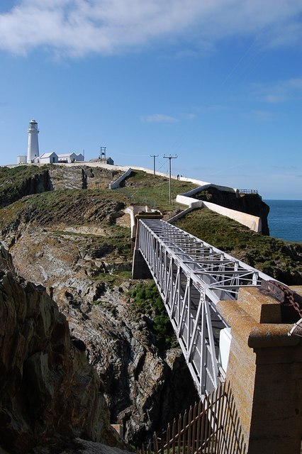
'The bridge across to South Stack Lighthouse, Anglesey' © Copyright Clive Perrin and licensed for reuse under this Creative Commons Licence.
There has been a lighthouse at South Stack since 1809. It is now a popular tourist attraction. The landward approach to the bridge is by descending 400 steps cut into the cliff face, then crossing an aluminium footbridge, which was completed in 1997.
×Great Orme
Contribution by: Susie Mowatt
The Great Orme is a tied island, connected by a tombolo to the north coast of Wales. It rises 207m straight out of the sea, looming over the Victorian seaside town of Llandudno. Made of limestone, it is similar to the Little Orme, a smaller tied island on the eastern side of Llandudno. Both areas are popular with rock climbers, and cliffs have been equipped with steel bolts for ‘sport’ climbing. Some routes are only accessible at low tide.
Earning its English name, which originally came from the Old Norse word for sea serpent, which it vast form resembles, it is thought to have been there for over 350 million years, meaning it is of great interest for its fantastic geology, archaeology, wildlife and history.

'Great Orme Tramway' © Copyright David Dixon and licensed for reuse under this Creative Commons Licence.

'Zig Zag Road on the Great Orme' © Copyright Ruth Sharville and licensed for reuse under this Creative Commons Licence.
Its amazing landscape allows for many different habitats, amongst these are heathlands to steep sea cliffs and limestone prairie to deep forests. The different terrain encourages many variety of plants and wildlife species to live there, for example choughs and the silver-studded blue butterfly.
On the Great Orme is Britain’s only cable-hauled public road tramway, which has attracted tourists since it opened on July 31st 1902. Beginning at the Victorian station the tram travels 1500 meters to the summit of The Great Orme to allow travellers to take in its stunning views
×Morecombe Bay/ Solway Firth
Morecambe Bay is a large multiple estuary, not a bay as the name suggests. It is the largest expanse of intertidal mudflats and sand in the UK covering a total area of 310 km2 (120 sq mi). In 1974 the second largest gas field in the UK was discovered 25 miles (40 km) west of Blackpool. At its peak 15% of Britain's gas supply came from the bay but production is now in decline and the main field was mothballed in 2011. There have been royally appointed local guides (holding the post of Queen's Guide to the Sands) for crossing the bay for centuries. The difficulty of crossing the bay added to the isolation of the land to its north which, due to the presence of the mountains of the Lake District, could only be reached by crossing these sands or by ferry, until rail access from 1857.
The bay is notorious for its quicksand and fast moving tides (it is said that the tide can come in "as fast as a horse can run"). On the night of 5 February 2004, 23 Chinese immigrant cockle pickers drowned after being cut off by the tides. This tragedy led some commentators to suggest that the cockle beds should be closed until improved safety measures could be introduced.

'Morecambe Bay, view from Hest Bank at low tide' © Copyright Malc McDonald and licensed for reuse under the Creative Commons Licence.

'Cockles' © Copyright Féron Benjamin and licensed for reuse under Creative Commons Licence
Morecambe Bay was featured on the television programme Seven Natural Wonders (BBC) as one of the wonders of the North.
×Arran
Contribution by: Susie Mowatt
The Isle of Arran is a beautiful little Scottish island located off the south-west coast of Scotland. At 20 miles long and 56 miles round, Arran is the seventh largest Scottish island. It has a small population of 4,600 inhabitants, however, this number doubles in the summer when the tourists come over and take up residence in the many holidays homes located around the island.
Arran is unique in that the Gulf Stream causes it to have a very mild climate, so much so that palm trees can grow there. Arran is often described as Scotland in miniature as it seems to offer everything, from rugged peaks, to lower lying moor land. Its many scenic villages and vast amount of amazing scenery and wildlife creates a stunning island to explore.
Travel is fairly easy with a direct train link from Glasgow to Ardrossan where the ferry leaves from. As Arran is within easy reach of Glasgow it makes an ideal place for holidays for people of different ages.

'Goat Fell, the highest point on the Isle at 874 m, seen from the sea' © Copyright Clydecoast and licensed for reuse under the Creative Commons Licence.

'Holy Isle, connected to Arran by a short ferry ride.' © Copyright Peter Ward and licensed for reuse under the Creative Commons Licence.
Arran has many different things to attract visitors: castles, whisky distilleries, wildlife and many outdoor activities. It boasts Scotland’s first ‘No Take Zone’ on the east side of the island in Lamlash Bay. This was developed by community consensus, and has been in place since 2008. This makes it a very inviting place for divers to come and see how the sea bed is recovering.
The two islands around Arran, Holy Isle and Pladda, make for nice places to kayak, sail or motor around. The many different species of animals that inhabit the land or sea are a delightful sight if you are lucky enough to see some. Holy Isle, once a Christian stronghold, is now home to the Centre for World for Peace and Health, a multi faith retreat centre with Buddhist roots.
×Small Isles
The four main islands are Canna, Rùm, Eigg and Muck. The largest is Rùm with an area of 41 square miles (110 km2).
Notably, Eigg generates virtually 100% of its electricity using renewable energy. Tourism is important to the local economy, especially in the summer months. A new building near the jetty houses the island's shop and post office, Galmisadale Bay restaurant and bar, a craft shop, and toilet and shower facilities, which are open 24 hours a day.
The island of Rum is owned and managed as a single estate by Scottish Natural Heritage (SNH). In the 1990s, residents and the SNH agreed that the best way to create a sustainable, self-reliant community would be to focus on Rum as a tourist destination. Since 2007, the Isle of Rum Community Trust has promoted rural development and the reintroduction of crofting.

'Kinloch Castle, Rum' © Copyright Ashley Dace and licensed for reuse under this Creative Commons Licence.

'View of An Sgurr, Eigg' © Copyright Mick Garrett and licensed for reuse under the Creative Commons Licence.

'Southwest coast of Isle of Muck' © Copyright Dr Julien Paren and licensed for reuse under this Creative Commons Licence.
Canna and Sanday (which are connected by a sandbar at low tide) were left to the National Trust for Scotland (NTS) by their previous owner in 1981, and are run as a farm and conservation area. After attempts by NTS to populate the island, by advertising worldwide for skilled residents, 12 people left in 2011, and the only school closed.
Muck is the smallest island, at only 2.5 miles (4km) across. It has tourist accommodation of all standards.
×Skye
According to Lonely Planet, “Along with Edinburgh and Loch Ness, Skye is one of Scotland’s top-three tourist destinations”. Skye was once voted 4th best island in the world by National Geographic magazine. In 1995, the Skye Bridge, spanning the water from Kyle of Loch Alsh to the island, was opened, replacing the ferry service. The high toll fare, peaking at £11.70 return, were always controversial, and were scrapped in 2004 when the Scottish Parliament bought the bridge.
It is renowned for its natural beauty and offers plenty of wildlife, history, geology, mind-blowing scenery, hillwalking and a variety of other outdoor activities. The Black Cuillin, contains 12 Munros, and is a big draw for climbers and mountaineers. The range is recognised as having the closest thing to alpine climbing in the UK. Some popular routes are best accessed by boat, usually from Elgol.

'The Skye Bridge' © Copyright Martin Gorman and licensed for reuse under this Creative Commons Licence.

'Fast RIB leaving Elgol jetty, Black Cuillin and entrance to Loch Coruisk in the background' © Copyright Paul Hermans and licensed for reuse under the GNU Free Documentation License
The island is also known for a vibrant café and good food scene, along with arts and music. The influence of the sea is never far away with sea fishing and a wide range of other watersports being catered for on Skye. Wildlife cruises sail from various locations and visitors might be able to spot seals, dolphins, otters, golden eagles or sea eagles.
×Tiree
Tiree has a population of about 650. It is popular for surfing and windsurfing, having waters warmed by the Gulf stream and year round waves from the consistent Atlantic swell. The ‘Tiree Wave Classic’ is the UKs premier annual windsurfing competition, having reverted to national level from its place on the international circuit. The event has dedicated worldwide TV coverage and attracts hundreds of visitors to the island each year, making the Classic a significant annual economic driver for the island.

'Traigh Bail, one of Tiree's surf beaches' © Copyright Sue Jackson and licensed for reuse under the Creative Commons Licence.

'Modern adaptation of the black house with felt roof, Vaul, Tiree' © Copyright Becky Williamson and licensed for reuse under this Creative Commons Licence.
There are numerous beautiful white sandy beaches creating perfect conditions for surfing at all levels. There are several surf schools, and regular visits by university clubs. Tiree is one of the UK's sunniest places and, unusually for the west coast of Scotland, almost midge-free due to a constant breeze. Other industry includes farming and crofting . The island is also known for its vernacular architecture, with numerous black houses maintained in traditional style.
×Islay

'Laphroaig Distillery, on the shore of Islay' © Copyright Rappilio and licensed for reuse under the GNU Free Documentation License
Islay is the southernmost island of the Inner Hebrides of Scotland and is known as "The Queen of the Hebrides". It is the fifth-largest Scottish island and the seventh-largest island surrounding Great Britain, with a total area of almost 620 square kilometres.
Islay is famous for its numerous whisky distilleries, large populations of birds, beautiful beaches and many historical sites.
It is believed that the Irish monks first introduced the art of distillation to Islay, during the early fourteenth century. There are eight active distilleries and the industry is the island's second largest employer after agriculture. The distilleries operate various shops, tours, and visitor centres.
Tourism is essential to the Island’s economy: the resident population is 3,000. It is estimated that 56,000 summer visitors arrive each year- either by ferry or by air.
×St Kilda
The archipelago of St Kilda is the remotest part of the British Isles, lying 41 miles (66 kilometres) west of Benbecula in Scotland's Outer Hebrides. It is designated as a World Heritage Site, and is also a National Nature reserve. It is owned and managed by the National Trust for Scotland.
Inhabited since mediaeval times, illnesses brought by increased external contacts through tourism, and the upheaval of the First World War contributed to the island's evacuation in 1930. Currently, the only year-round residents are military personnel, a variety of conservation workers, volunteers and scientists spend time there in the summer months.

'St Kilda, Village Bay' © Copyright Ian Mitchell and licensed for reuse under the Creative Commons Licence.

'St Kildans sitting on the village street in 1886' Property of the National Trust for Scotland.
The UKs highest sea cliffs are found here, and form the most important seabird breeding station in north-west Europe.
There is no tourist accommodation on the islands, but there are moorings in Village Bay that are used by visiting yachts. Over the last decade an increasing number of divers and sea kayakers have been making trips out to St Kilda on small cruising ships, and basing themselves on board during their stay.
More recently, fast RIBS have been running day trips out to the islands from both North Uist and Harris.
×Northern Isles
The Northern Isles is a term for both the Orkneys and the Shetlands, although the two groupings have distinctive landscapes: the fertile agricultural islands of Orkney contrast with the more rugged Shetland islands to the north, where the economy is more dependent on fishing and the oil wealth of the surrounding seas. The climate is cool and temperate and much influenced by the sea.
Tourism is important to both archipelagos, with their distinctive prehistoric ruins playing a key part in their attraction, and there are regular ferry and air connections with mainland Scotland. The Scandinavian influence remains strong, especially in relation to local folklore, and many place names reflect Norse heritage.

'The Noup, Foula over Mucklebrik from above Ufshins, with the vertical cleft of da Sneck o da Smallie' © Copyright Dr Julien Paren and licensed for reuse under the Creative Commons Licence.

'Procession at Uyeasound Up Helly Aa Guisers follow the Guiser Jarl in the galley in the torchlit procession for Uyeasound Up Helly Aa.' © Copyright Mike Pennington and licensed for reuse under the Creative Commons Licence.

'Ring of Brodgar, Orkney, with cultivated land behind.' © Copyright Shadowgate and licensed for reuse under this Creative Commons Licence.
Orkney comprises 70 islands, 20 of which are inhabited. The significant wind and marine energy resources are of growing importance, and the island generates more than its total yearly electricity demand using renewables. The local people are known as Orcadians and have a distinctive Scots dialect. There is an abundance of marine and avian wildlife. Orkney produces and exports beef, cheese, whisky, beer, fish and other seafood. In recent years there has been growth in other areas including tourism, jewellery, knitwear, and other crafts production.
The Shetlands are an archipelago, which has an oceanic climate, a complex geology, a rugged coastline and many low, rolling hills. The ‘Mainland’, plus 15 other islands are inhabited. Up Helly Aa is a tradition that originated in the 1880s, and takes place every Januray. The world famous torchlit procession typically consists of nearly one thousand guizers who carry their Torches through the town, following the Galley along the route towards its fiery end and Valhalla. The route is lined with spectators, who on a good night may number over five thousand strong. This is a fantastic off season boot to Shetland’s economy.
×Bass Rock
Contribution by: Rosie Fortnum
Bass Rock is an uninhabited island. This large rock was formed 320 million years ago and is actually the core of an old volcano. It stands over 100m tall and is surrounded mostly by steep cliffs and rocks. The gentler slope to the south forms a lower promontory where the ruins of a castle stand, dating back to at least 1405. There is also a light house on Bass which was built in 1902 and has been unmanned since 1988 as it is now remotely monitored from the main land.

'Bass Rock Lighthouse from above, with Gannet colony in the foreground' © Copyright Stanley Howe and licensed for reuse under the Creative Commons Licence.

'Bass Rock taken from a microlight' © Copyright Lisa Jarvis and licensed for reuse under the Creative Commons Licence.
The island is home to the largest Northern Gannet colony in the world. Around 150,000 live on Bass Rock until the end of October when the gannets fly south. When all the gannets are on Bass the island appears white due to the large numbers. The lower ledges are home to other sea birds such as Guillemots, Razorbill and Shags.
The wildlife on Bass Rock can be viewed from online web cams which have been set up by the Scottish Seabird Centre to monitor the gannets. It is also possible to take commercially run boat trips around the island. Permission to land, granted by the Scottish Seabird Centre, is only given in special circumstances.
×Lindesfarne
Contribution by: Kara Scott
Lindisfarne, otherwise known as Holy Island, is located just a few miles off the Northumberland coast, about 10 miles south of Berwick-upon-Tweed. To get there you go along a tarmaced causeway which is only accessible when the tide is low. Access to Lindisfarne is cut off twice-daily and it is important to pre-plan your trip before you go. In 635AD Saint Aiden came from Iona and chose to found his monastery on Lindisfarne.
Holy Island became the cradle of English Christianity and the Christian message flourished here and spread throughout the world. Furthermore, the island was one of the first places in Britain to be ransacked by marauding Viking raiders in 793AD. Lindisfarne castle was built during the 16th century to defend the island.

'Lindesfarne Castle' © Copyright David Armstrong and licensed for reuse under the Creative Commons Licence.

'Brent Goose in defensive position' Taken by Tim Bowman, put into the Public Domain by the US Fish and Wildlife Service.
The castle walls were strengthened with yak hair to stop the rain from eroding them. Not only is Lindisfarne a historical hub, but it is also a wildlife hub. The natural reserve on the island is home to important wintering bird populations. The reserve is the only winter nesting place for the Norwegian pale bellied brent goose. The coastline is also home to many common seals and there are commercial boats which take people out to have a closer look.
×Farne Islands
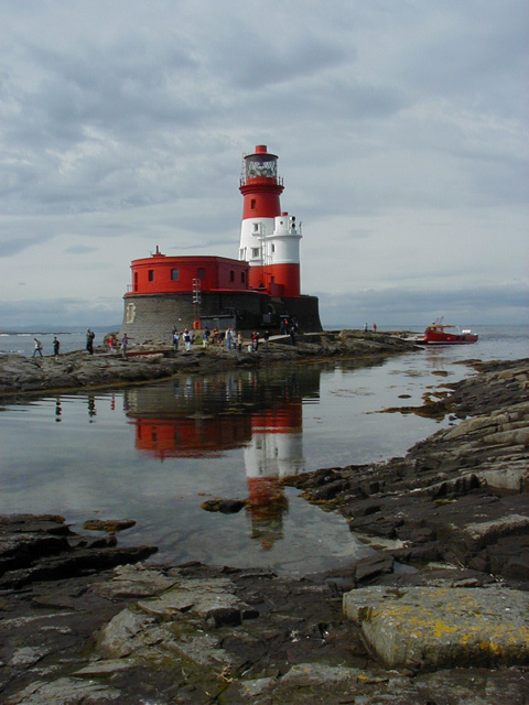
'Lighthouse on the Farne Islands' © Copyright Paul Sexton and licensed for reuse under the Creative Commons License.
The Farne Islands are a group of between 15 and 20 islands, depending on the state of the tide, which are owned and managed by the National Trust. They were once declared by broadcaster Sir David Attenborough as his favourite place in the UK to see nature at its best. The NT promote opportunities to view seabirds at ‘unbelievably close range’, with 100,000 nesting seabirds and their chicks in the breeding season, including puffins, terns, guillemots, eider ducks and many others. There is also the Chapel of St Cuthbert, with fine stained-glass windows, and unrivalled views of the Northumberland coast and countryside.
The Farne Islands are a popular scuba diving location, with a variety of sites suitable for all levels of diver. The islands appeal to divers for the seals and wrecks. The grey seal colony at the Farnes numbers about 5,000. They are curious and will often look in on divers in the water and are impressive to watch underwater.
Tourist access is by boat trip from Seahouses on the Northumberland coast.
×Scilly Isles
Contribution by: Fiona Christian
The Isles of Scilly are an archipelago of 140 islands, 28miles south west off the Cornish peninsula. Only the 5 largest islands are inhabited, St Mary's, St Martin's, St Agnes, Tresco and Bryher, with a total population of 2280.
Access to the islands by air is to the heliport on St Mary's aboard the Isles of Scilly Airbus or by helicopter both from Penzance. By sea the Isles of Scilly Steamship Company operate the Scillonian III ferry to St Mary's harbour which is the principle harbour of the Isles of Scilly and access to the other islands are by launches and tenders from here.
The islands are renowned for their warm and sunny climate where the average temperature is 11.8oC . There are more than 35 sandy beaches with miles of pale fine sand. The Great Bay on St Martin's has been voted the best in the UK for swimming. There are also many steep rock faces and deep inlets making the Scilly Isles a diverse geological area.
There are many marine based activities such as diving in one of the finest dive sites in the UK with 900 shipwrecks both ancient and modern, or to get close to Scilly's seals with a snorkelling trip, dinghy sail, kayak or by windsurfing.

'Looking across Tresco, one of the 5 inhabited islands of the Isles of Scilly ' © Copyright Tom Corser and licensed for reuse under the Creative Commons Licence.

'A lineup of gigs on St. Mary's, Isles of Scilly during the world pilot gig championships' © Copyright Tom Corser and licensed for reuse under the Creative Commons Licence.
Sea swimming is very popular, and a number of organised sea swims are organised throughout the year, ending with the annual Sea Swim Challenge of swimming between all the islands in one day. The Islands Partnership have just secured the first UK based qualifying event for the ÖTILLÖ (island to island, pronounced ur-till-ur) Swim-Run event, a 75km mix of trail running and open water swimming held annually in Sweden. It is ranked as one of the toughest endurance races in the world by CNN. The Scilly Isles version covers 45km, with 10km of swimming, and is expected to bring thousands of additional visitors and tens-of-thousands of pounds into Scilly’s economy over the next decade.
×Isle of Man
Contribution by: Hanna Ehlers
The Isle of Man is a self-governing British Crown dependency located in the Irish Sea. It is very well known for its annual motorcycle race called the Isle of Man Tourist Trophy (known as the ‘TT’).
It has a varying landscape. The coastline stretches for 100 miles where you can find long sandy beaches, rocky cliffs and sheltered bays. The Island’s only mountain is called Snaefell and is 620m above sea level. There are also a number of smaller islands located off the Island’s coast (e.g. Calf of Man and St Patrick’s Isle). You’ll also find eighteen ‘National Glens’, a designation of the Manx Government, which maintains land in a semi wild state.

'Calf of Man, taken from Cregneash' Taken by Eric Bobson and released into the public domain

'Isle of Man flag'
For people who are interested in wildlife watching the island offers various opportunities. The Calf of Man is home to a nature reserve and bird observatory, and to seals which bask on the rocks in the surrounding water. There are two domestic animals specifically connected to the Isle of Man: the Manx Cat which is noted for having a shortened tail and the Manx Loaghtan sheep which has four, or sometimes six horns.
The Isle of Man also offers a wide range of different outdoor activities. It is a good place for cycling and mountain biking with numerous trails for riders of all abilities. It’s also renowned for its walking scene with a wide range of mountainous trails, long distance footpaths and a coastal path. Other outdoor activities include kayaking, sailing and golf.
×St Ninian's Isle, Shetland
Contribution by: Brodie Samuel-Garritt
St Ninian’s is a small island located on the west coast of Shetland. It is connected to the mainland by the largest tombolo in the UK; a natural sand causeway formed by years of sand deposition.
People choose to travel here to view the stunning scenery and picturesque beaches. The tombolo may be crossed throughout the year, excepting at high tide, when the centre of the tombola may become submerged. The island contains an archaeological site, where a hoard of silver from the 8th century was found in 1958. This is the best preserved silverware from that period to have been found in Scotland, and is thought to be connected to the Viking raids. There is also a ruined 12th century chapel.

St Ninian's Isle Treasure/ CC BY-SA 3.0

Tombolo connecting St Ninian's Isle to mainland Shetland/ CC0 1.0
The island and beach are both easily accessible via the village of Bigton which contains a small local village shop.
×Isle of Canna
Contribution by: Kathryn MacKinnon
The island of Canna and the neighbouring island of Sanday are part of a group of islands called the Small Isles. Canna and Sanday have passed from Viking rule, to Lairds and are now owned and maintained by the National Trust for Scotland. They are connected to each other by a road bridge, and to the mainland by a lifeline ferry service. Between them, they have less than thirty inhabitants, an enormous change from before the clearances when over 400 people lived on the islands.

'Tarbert Bay, Isle of Canna'. © Copyright Julian Paren/ CC BY-SA 2.0
Canna has a great diversity of wildlife; basking sharks can be seen from early May to Late August, Seals, Otters, Seabirds; including puffins and gannets, and several pairs eagles nesting on the vaulting sea cliffs of the north side of Canna.
As well as wildlife, the islands have some fantastic scenery to offer; Corrigan Beach is a favourite photo destination as the black volcanic sands would be more expected of the Canary Islands than the Small Isles. Basalt columns are another indicator of the volcanic past of the islands and can be seen both on the sea stacks and crowning the white sand beaches of Sanday and Tarbert bays.
×The Monach Islands
Contribution by: Kathryn MacKinnon

'Northern part of Ceann Iar, one of the Monach Islands.'. © Copyright Bob Jones/ CC BY-SA 2.0
The Monachs, also known as Heiskier, are a group of six islands, which have been uninhabited since 1948. The population once peaked at 130 people. Ceann Ear Island was once home to a nunnery, and in 1864 a lighthouse was built on Shillay and was run by monks; this was later replaced in 1963 with an unmanned light.
The legend surrounding the Monachs, is that they were once connected to the mainland, but a great storm washed away the sandbank, leaving the islands stranded in the Atlantic Ocean.
In 1966, the islands were declared a National Nature Reserve and boast population of approximately 10,000 grey seals, one of the largest in the world.
×Fort William
Fort William (Scottish Gaelic, An Gearasdan: "The Garrison") is the second largest settlement in the Highlands of Scotland after Inverness, with around 10,000 inhabitants. The name, given to the small military stronghold in 1690, came to represent the town that grew around it. It was named after William of Orange, who held the crown when the fort was built, and formed a line of presence along the Great Glen, along with Fort Augustus and Fort George, outside Inverness. The ruins of the original fort lie next to the West Highland College campus, on the shore of Loch Linnhe.
The town lies in the shadow of Ben Nevis, the highest mountain in Britain at 1344m. Fort William is self-styled as the ‘Outdoor Capital of the UK’, as it is an excellent gateway to many activities and natural resources. It is also home the The Underwater Centre, which specialises in training commercial divers.

'Corpach Sea Lock on the Caledonian Canal Scotland' © Copyright WyrdLight.com and licensed for reuse under the Creative Commons Licence.

'Fort William, with Ben Nevis behind, taken between 1890 and 1900' Image in public domain.
Fort William is at the end of the West Highland Way, which stretches 96 miles south to the outskirts of Glasgow, and the Great Glen Way, heading 79 miles north east to Inverness. The Great Glen can also be traversed by boat, by a system of canals and locks which form the Caledonian Canal. This brings many international boats through the area, which as yet, have little reason or opportunity to stop here. There is currently a push to develop a marina at Corpach (by start of the Caledonian Canal), with 80 berths or various sizes, and associated facilities. This project has not been given a timescale yet. Meanwhile, the Fort William Marina and Shorefront Association have secured funding from the Town Centre Community Capital Fund to build a double pontoon at the West End Carpark. This will allow large cruise ships to visit, and is expected to provide a great economic boost for the town.
×Gairloch
Gairloch has made itself a hub for marine tourism. It has a selection of beautiful beaches, and accommodation is mostly self catering, small guest house or camping. Along towards the pier, Gairloch boasts a scene more familiar outside of the UK: there are multiple boat tour operators with shop front presence, vying for tourists' spend. The trips vary from the #1 Trip Advisor ranked Sealife Glass Bottom Boat Cruises inside the bay (£18.50 per adult, 2015), to the Hebridean Whale Cruises which utilise a powerful RIB, to zoom tourists out into the Minch and the Shiant Islands to find the marine mega fauna (49.50 per adult for their shortest trip). There are also boats suitable for in between trips, and accordingly priced.

'Looking across the town beach at Gairloch' © Copyright David Crocker and licensed for reuse under the Creative Commons Licence.

'A selection of the boats in Gairloch harbour, which offer a variety of trips in and outsdie of the bay.' © Copyright Richard Dorrell and licensed for reuse under the Creative Commons Licence.
John O'Groats

'Signpost at the end of the trail, John O'Groats' © Copyright Christine Matthews and licensed for reuse under the Creative Commons Licence.
A small village that is at one end of the longest distance between two inhabited British points, with Land's End in Cornwall lying 876 miles to the southwest. “LeJog” (Land’s End to John O’Groats) is a popular challenge for cyclists and walkers, and increasingly being completed as a part of large, organized evets for charity fundraising. The Hotel keeps a logbook which can be signed by successful “end to enders”
It is not quite the most northerly point on the island of Britain; nearby Dunnet Head is further north.
The harbour opens out onto the Pentland Firth, and some of the UK’s fastest tides. Not a suitable spot for general water based recreation, but a launch spot for expert kayakers looking to cross to Orkney or to explore the now uninhabited islands of Stroma and Swona en route.
A passenger ferry service can take the less adventurous tourist over to Orkney in 40 mins.
×Dover
Established in 1606, the Port of Dover is Europe’s busiest ferry port, a vital international gateway for the movement of passengers and trade. It faces France across the narrowest point on the English Channel. It is also an award-winning cruise port, the second busiest in the UK and hosts some of the world’s most prestigious cruise lines. Other successful businesses include a cargo terminal, a top award-winning marina and several niche activities.

'The famous white chalk cliffs of Dover, seen from the sea' © Copyright Immanuel Giel and licensed for reuse under the Creative Commons Licence.

'Dover Castle' © Copyright Webzooloo and licensed for reuse under the Creative Commons Licence.
Dover’s history, because of its proximity to France, has always been of great strategic importance to Britain. Archaeological finds have shown that there were Stone Age people in the area; and that by the Bronze Age the maritime influence was already strong. The coming of the Romans made Dover part of their communications network. Dover Castle was founded in the 11th century and has been described as the "Key to England" due to its defensive significance throughout history. It is the largest castle in England, and is now managed by English Heritage as a tourist attraction. There are a variety of other historic and natural attractions for visitors.
English Heritage: Dover Castle
Port of Dover
Eastbourne, Beachy Head
With a seafront consisting largely of Victorian hotels, the pier, and a Napoleonic era fort and military museum, Eastbourne was developed by the Duke of Devonshire in 1859 from four separate hamlets. It has a growing population, and a broad economic base.
As a seaside resort, Eastbourne derives a large and increasing income from tourism, with revenue from traditional seaside attractions augmented by conferences, public events and cultural sightseeing. The pier is a popular attraction and is sometimes used to hold events, such as the international Birdman competition held annually, where competitors attempt to ‘fly’ off the end of the pier using home-made aircraft. It was built between 1866 and 1872, and is around 300m (1000ft) long. It has variously held theatres, saloons and other structures, despite suffering from storm damage and fire. In July 2014, fire damaged nearly one third of the pier. Major works allowed the pier to open for the 2015 summer season.

'Eastbourne Pier at sunset' © Copyright T appletart and licensed for reuse under the Creative Commons License

'Beachy Head: Looking towards the cliffs and lighthouse from the west near Birling Gap' © Copyright David Iliff and licensed for reuse under the Creative Commons Licence.
A major event in the tourist calendar, now the world's biggest seafront air show, is the annually held 4 day, international air show, 'Airbourne'. To the west of the town lies Beachy Head, known for the tallest chalk cliffs in Britian.
Visit southeast England: Eastbourne
Solent and the Isle of Wight
The Solent is the strait that separates the Isle of Wight from the mainland of England. It is about 20 miles in length and varies in width between one and four miles.
The Solent is a major shipping route for passenger, freight and military vessels. It is an important yachting area, hosting the Cowes Week sailing event annually. It is sheltered by the Isle of Wight and has a very complex tidal pattern, which provides Southampton with a "double high tide" that extends the tidal window during which deep-draught ships can be handled.

'Looking towards Little Stairs Point, Shanklin, Isle of Wight' © Copyright Christine Matthews and licensed for reuse under the Creative Commons Licence.

'The Spinnaker Tower, Portsmouth, from the Gosport Ferry. An iconic sight from the Solent.' © Copyright Unisouth and licensed for reuse under theGNU Free Documentation License
The area is of great ecological and landscape importance, particularly because of the coastal and estuarine habitats along the edge of the Solent. Much of its coastline is designated as a Special Area of Conservation. It is bordered by and forms a part of the character of a number of nationally important protected landscapes including the New Forest National Park, and the Isle of Wight AONB.
×Southhampton
Southampton has always been a port, and the docks have long been a major employer in the city. In particular, it is a port for cruise ships; its heyday was the first half of the 20th century, and in particular the inter-war years, when it handled almost half the passenger traffic of the UK. Today it remains home to luxury cruise ships, as well as being the largest freight port on the Channel coast. Many of the world's largest cruise ships can regularly be seen in Southampton water, including record-breaking vessels from Royal Caribbean and Carnival Corporation plc. The latter has headquarters in Southampton, with its brands including Princess Cruises, P&O Cruises and Cunard Line.
Southampton is home to the headquarters of both the Maritime and Coastguard Agency and the Marine Accident Investigation Branch of the Department for Transport. The annual Southampton Boat Show is held in September each year, with over 600 exhibitors present. It runs for just over a week at Mayflower Park on the city's waterfront, where it has been held since 1968.

'Allure of the Seas, along with her sister ship Oasis of the Seas, they are the biggest cruise liners int eh world. Home port Southampton.' © Copyright Daniel Christensen and licensed for reuse under the Creative Commons Licence.

'Southampton container port at night, close to low tide' © Copyright Geni and licensed for reuse under theGNU Free Documentation License
The city was the subject of a BBC programme called Sea City, focussing on commercial activity in the docks.
×Weymouth
Studland Bay, Dorset, is part of a network of one hundred and twenty seven coastal areas across Britain that could receive protection after the government made efforts to start protecting important species and seagrass habitats in the Marine and Coastal Access Act of 2009. This is also a popular area for anchoring for sailing yachts, which has cause some friction between conservation and recreation in the area.

'Weymouth beach' © Copyright Ytfc1895 and licensed for reuse under the Creative Commons License

'Portland Marina' © Copyright Raimond Spekking and licensed for reuse under the Creative Commons License
Weymouth and Portland is another excellent sailing and recreational area. It hosted the 2012 Olympic sailing and it is in area that has benefited from the games legacy.
×Rhyl
Rhyl currently brands itself as the ‘Family Fun Centre of North Wales’. Once an elegant Victorian resort, there was an influx of people from Liverpool and Manchester after the Second World War changing the face of the town. The area had declined dramatically by 1990, becoming a symbol of the the failed seaside resort, and failing to stay as attractive as Llandudno and others along the coast. Where Llandudno successfully mixed the Victorian feel with modernity, Rhyl opted for fairground style attractions and bright lights, but without the budget to pull it off. The town has since improved due to a series of regeneration projects bringing in major investment. European funding, secured by the Welsh Government, has produced millions for the development of Rhyl's seafront.

'Ocean Beach Funfair site in 2007' © Copyright Wonderwiki and licensed for reuse under theGNU Free Documentation License

'Rhyl promenade, c. 1870' Image is in the public domain
Marine Lake, an artificial excavation in the west of the town, used to be a tourist destination, with fairground rides and a zoo. The lake is a 12 hectares man-made reservoir and it was officially opened in 1895. Rhyl Miniature Railway is the only original attraction remaining on the site. There is also a playground and numerous watersports clubs based around the lake.
The town is an example of what can be achieved with funding and vision.
×Liverpool
Set on the River Mersey, Liverpool’s Waterfront was granted World Heritage Site status by UNESCO, in 2004. The city’s bid was centred on Liverpool as a maritime mercantile city, and reflected the city’s significance as a commercial port, at the time of Britain’s greatest global influence.
Liverpool's first dock was the world's first enclosed commercial dock, the Old Dock, built in 1715. The Lyver Pool, a tidal inlet in the narrows of the estuary, which is now largely under the Liverpool One shopping centre, was converted into the enclosed dock.
The largest dock, Seaforth Dock, was opened in 1972 and deals with grain and containers, accommodating what were the largest containers ships at that time.

'Liverpool waterfront. Mersey river festival from the maritime museum' © Copyright Alan Fairweather and licensed for reuse under Creative Commons Licence

'Detail view of the Royal Liver Building, photographed from the Mersey Ferry as it approaches the Pier Head.' © Copyright William Starkey and licensed for reuse under Creative Commons Licence
Both White Star Line and Cunard Line were based at the port. It was also the home port of many great ships, including the ill-starred RMS Lusitania and the RMS Titanic.
The Royal Liver Building is one of Liverpool’s ‘Three Graces’: three iconic buildings with rich maritime history, which overlook the water. When built in 1911, it was the tallest building in Europe. It is said that if ever one of the Liver birds flies away, the city would cease to exist.
Today the port is one of Britain's largest, providing passenger ferry services across the Irish Sea to Belfast, Dublin and the Isle of Man. In 2007, a new cruise terminal was opened in Liverpool, located alongside the Pier Head in the city centre.
×Lerwick
Contribution by: Michael Bundgaard

'Victoria pier, Lerwick' / CC BY-SA 2.0
Founded as an unofficial marketplace to service 17th century Dutch herring fleets, Lerwick took a long time to grow. Because of its illegal status the straggling hamlet around the shore of Ler Wick ('muddy bay') was demolished by order of the Scalloway court in 1615 and 1625. The Dutch burnt the fort in 1673 and the French set fire to Lerwick in 1702.
Even though Lerwick’s past was tough it is Shetland's only town, with a population of about 7,500, although about half of the islands' 22,000 people live within 10 miles of the burgh. With a proud maritime heritage and ancient Norse roots, this settlement has grown slowly but surely and is now a bustling port for trade, business and visitors to the isles.
Lerwick is an ideal place to test your skill in sea kayaking, canoeing and photography and also get introduced to the best-known and the less-known wildlife around the coasts, due to its natural environment that is home to seabirds to sea urchins, towering cliffs to hidden caves, grey seals and even purple starfish.
The town has an excellent leisure centre, with a swimming pool, two cinemas showing a very wide range of films as well as an excellent auditorium that hosts live music and a café-bar. Visitors can explore a surprisingly wide range of well-stocked shops. Lerwick also has an outstanding Museum and Archives, incorporating an art gallery.
×Inverness
Contribution by: Chris Webster

'Inverness Castle and River Ness' / CC BY 2.0
Inverness is the only city in the Scottish Highlands, and is regarded as its capital. It is one of Europe's fastest growing cities, with a quarter of the Highland population living in or around it, and is ranked fifth out of 189 British cities for its quality of life, the highest of any Scottish city.
The city is a tourism hub, branded the Gateway to the Highlands, with its own airport. It is at the mouth of Loch Ness, and the site of Culloden, where the last ever battle was fought on British ground in 1745.
From the city, it is possible to access many activity options. There is also a lively nightlife, and a wide selection of shops.
Inverness is also a large hub for transporting cargo. Its port has recently become the UKs main port for taking in new wind turbines, which are then transported all round Scotland.
×Caribbean
Contribution by: Susie Mowatt
The Caribbean is a beautiful area consisting of 700 islands, islets, reefs and caves. Of the hundreds of islands only about 2% of them are actually inhabited. The Islands in the Caribbean have a variety of spoken languages, but the dominant languages are English, Dutch and Spanish, due to a colonial past. Originally, when the Caribbean was found by Columbus, the existence of the Americas was unknown. He thought he had reached Asia, and called the area the West Indies. The inhabitants of the Caribbean mainly come from African slaves who the Europeans sent there to work on the sugar plantations. After slavery ended they continued living on the islands and made them their home.

'The Caribbean Princess' © Copyright liomere and licensed for reuse under the Creative Commons Licence.

'Beach side gift shop' © Released into the Public Domain by the Copyright holder, Romi
The Caribbean’s location and warm climate create an amazing place to experience various outdoor activities. Snorkelling and diving on its many reefs is a great experience to try. The Caribbean has many beautiful anchorages off various islands, making it a fantastic place to go yachting. The region has long been associated with jet setters and celebrity, with luxury resorts and privately own retreats. Its image is further enhanced through film connections: there were parts in all four of the Pirates of the Caribbean films which were filmed there, along which a scene from the very first Bond film, Dr No.
×Galapagos
Contribution by: Hanna Ehlers
The Galápagos Islands are part of Ecuador and an archipelago of 19 volcanic islands, distributed on either side of the Equator in the Pacific Ocean. Around 30,000 people live on the islands, and approximately 170,000 tourists visit the islands each year. In 1973, it was decided that the visitor limit should be 12,000 annually, or resources would be destroyed. Economic pressures pushed this number up, until in 1996 the total number limit was lifted in favour of a more complex scheme which aims to spread the burden across sites. Most tourists arrive by cruise ship. Ships with more than 20 passengers must follow strict schedules.
The islands are very famous for their high number of endemic species, like land iguana, the giant tortoise and the many types of finch. There is also the Galápagos Marine Reserve which is an underwater wildlife spectacle with great life ranging from corals to sharks to penguins to marine mammals. The islands also have an unusual plant life with huge cacti and endemic trees. Charles Darwin famously visited aboard the Beagle in 1835, when the seeds were sown for his theory of evolution by natural selection.

'Galapagos Land Iguana' © Copyright Magnus Manske and licensed for reuse under the Creative Commons Licence.

'Galapagos Penguin' © Copyright Randal Shepperd and licensed for reuse under the Creative Commons Licence.
The 19 islands and the surrounding marine reserve have been called a unique ‘living museum and showcase of evolution’, and have been designated a UNESCO World Heritage site.
The main reasons for visiting the Galápagos Islands are wildlife watching, diving and hiking and biking to the volcanoes. The Galapagos Marine Reserve offer a great experience of diving with such a diversity of marine life forms that are so familiar with human beings, that they accompany divers. The diversity of underwater geomorphological forms is an added value to the site producing a unique display, which cannot be found anywhere else in the world.
×Great Barrier Reef
Contribution by: Kara Scott
The Great Barrier Reef is designated a UNESCO World Heritage site, and was voted one of the Seven Natural Wonders of the World in a 1997 poll by CNN. It is blessed with the breathtaking beauty of the world’s largest coral reef, which is the only living thing on earth visible from space. The reef consists of approximately 3000 individual reef systems, and 880 picturesque tropical islands with some of the world’s most beautiful sun-soaked, golden beaches. But the most riveting sight of all—and the main reason for World Heritage status—is the vast expanse of coral. It is also home to hundreds and thousands of different types of plant, bird and marine life, and holds great scientific interest as the habitat of species such as the dugong (‘sea cow’) and the large green turtle, which are threatened with extinction.

'The Great Barrier Reef from space' © Copyright NASA and licensed for reuse under the Creative Commons Licence.

'Dugong, or 'sea cow'' © Copyright Julien Willem and licensed for reuse under the GNU Free Documentation License
Because of its natural beauty and variety in wildlife, the Great Barrier Reef has become one of the world’s most sought after tourist destinations. A visitor to the Great Barrier Reef can enjoy many experiences including snorkelling, scuba diving, aircraft or helicopter tours, bare boats (self-sail), glass-bottomed boat viewing, semi-submersibles and educational trips, cruise ship tours, whale watching and swimming with dolphins. There are an array of different companies providing such experiences and hundreds of accommodation providers all along the tropical north Queensland coast. Due to rising numbers of visitors and destructive weather patterns it is important to protect the reef. To ensure this, the Great Barrier Reef Marine Park Authority (GBRMPA) strive to ensure all human uses of the Park are ecologically sustainable and that the ecosystem's natural functions, especially resilience, are maintained.
Great Barrier Reef: Marine Park Authority
Austrailian government - Great Barrier Reef Information
Great Barrier Reef: Cruises
Hawai'i
Contribution by: Angus Jenkins
Hawaii is a group of eight islands, seven of which are populated, by just under 1.5m people. The islands, which rise to over 3,000m above sea level, became the 50th state of the USA in 1959. Two thirds of the population live on O’ahu, where the State Capital Honolulu lies. Hawaii was created by undersea volcanic activity in the ‘Hawaiian hot-spot’, and eruptions continue to occur every year. Hawaii has spectacular diverse scenery, hot tropical climate, miles of open beaches and marine environment which is a wonderful playground for tourists, surfers, volcanologists and biologists. It is also home to the Institute for Astronomy, as the low light pollution affords an unparalleled opportunity to look into the skies.

'Hawaii coast line' © Copyright tpsdave and licensed for reuse under the Creative Commons License

'Surfing a 'Big Wave'' public domain image.
There are many activities that attract tourists to the group of islands such as volcanoes, cuisine, hula and the surf. Hawaii is well known for its surfing and is said to be the birthplace of big wave surfing. One of Hawaii’s protected areas is a Marine National Monument called Papahanaumokuakea. This was created in 2006, and is a UNESCO World Heritage site. It is one of the largest protected areas in the world, and is larger than all of the US land based parks put together. The park is home 7,000 marine species, some of which are endangered. The area is also of great importance to Native Hawaiians.
×Kiribati
Contribution by: Kag Gannon
The country of Kiribati is a collection of 33 coral islands in the central Pacific Ocean. The island nation has been prominent in the climate change debate owing to the average height above sea level being just 6 meters.
In recent years there has been investment in key infrastructure such as air and sea ports. This has brought additional air connections from Australia. The country has also invested in its domestic routes, further opening up the islands to tourist activity.
Kirimati Island, also known as Christmas Island, is the largest coral atoll in the world at 642 km squared. The island was discovered by the Spanish in 1537 but was re-discovered by James Cook on Christmas Eve in 1777. As the island was uninhabited at that time those who did settle used the English name, but altered the spelling.

'Symbiotic algae in the coral reefs of Endenbury Island' © Copyright Karya sendiri and licensed for reuse under the Creative Commons License

'Butaritari, Kiribati' © Copyright KevGuy 4101 and licensed for reuse under the Creative Commons Licence.
Kirimati has a surf season lasting from March to October. The waves are suitable for beginners through to the experienced, and break along a 5 km stretch of golden coastline. Scuba diving and fishing is also popular, records have been broken for the size of bonefish caught in these waters.
During the Second World War there was intense fighting and as such there are now historical relics to be seen on the beaches of Tarawa, the capital island. This island nation has great resources to offer over the 26 inhabited islands, and is an area of great variety, unspoilt by commercial tourism. Visit for cultural, historical and marine experiences before the crowds arrive!
×Madagascar
Contribution by: Rachel Owen
Madagascar is the world’s 4th largest island, at nearly 593k km2. It has been independent since 1960, having formerly been a French colony. Official languages are French and Malagasy. Despite a high potential for tourism, tourism in Madagascar is underdeveloped, in part due to frequent political regime changes over the last few decades.

'Nosy Iranja, Madagascar' © Copyright Moongateclimber and licensed for reuse under the GNU Free Documentation License

'Image of Tolagnaro' Released into the Public Domain by the Copyright holder, Henry Trotter
Madagascar's tourist attractions include its beaches and biodiversity. The island's endemic wildlife and forests are unique tourist attractions. Species such as the ring-tailed lemurs and the giant leaf-tailed gecko are found nowhere else in the world. Historical sites, craftsmen communities, and relaxed cities make it a favorite with return travellers. With over 70% of the country living in poverty, tourism is seen as a way to reduce poverty and provide economic growth. Madagascar’s seashore is about 5,000 km long. Its crystal clear waters are ideal for diving and snorkelling. The Agulhas Current warms the shallows and supports a variety of reef types, including barrier and bank reefs.
×Red Sea
Contribution by: Louise Anne Ferguson
The Red Sea is one of the saltiest bodies of water in the world. At its deepest it is over 2km, but there are extensive shallow shelves, noted for their marine life and corals. The sea is the habitat of over 1,000 invertebrate species, and 200 soft and hard corals. It is the world's northernmost tropical sea. Red Sea marine life is protected by reserves, though these only cover a tiny fraction of the area.
The Red Sea became a sought-after diving destination after the expeditions of Hans Hass in the 1950s, and later by Jacques-Yves Cousteau. Commercial activity is focussed in Egyptian sites. Lesser known sites are accessed from Sudan. The Red Sea holds many wrecks, some of which are very famous, others infamous. The SS Thistlegorm, the Dunraven and the Ulysses are just a few that are very popular to dive.

'Red Sea Anemonefish in Red Bubble Anemone' © Copyright Prilfish and licensed for reuse under the Creative Commons License

'Inside Dunraven wreck, Ras Mohammed Park' © Copyright Matt Kieffer and licensed for reuse under the Creative Commons License
The popular tourist beach of Sharm el-Sheikh, in Egypt, was closed to all swimming in December 2010 due to several serious shark attacks, including a fatality. Scientists investigating the attacks have identified, but not verified, several possible causes including over-fishing which causes large sharks to hunt closer to shore, tourist boat operators who chum offshore for shark-photo opportunities, and reports of ships throwing dead livestock overboard.
Almost all tourism businesses skirt the shore of the Red Sea and offer many water based activities in addition to diving. These include snorkelling, windsurfing, diving, sea safaris, sightseeing, kitesurfing and wildlife watching.
×Mediterranean
Contribution by Rosie Fortnum
The Mediterranean Sea is almost completely enclosed by land, except the 14km (8.7mi) wide Straits of Gibraltar, which connect it to the Atlantic Ocean. Its name has roots in latin, meaning ‘inland’ or ‘in the middle of the land’. With so many nations upon its shores, the sea was an important route for merchants and travellers of ancient times, allowing trade and cultural exchange between emergent peoples of the region. The history of the Mediterranean region is crucial to understanding the origins and development of many modern societies.
The average depth of the Mediterranean is 1,500 m (4,900 ft), but the deepest recorded point is 5,267 m (17,280 ft) in the Calypso Deep in the Ionian Sea. This allows for a wide variety of fauna and flora, with 20% of all marine species that can only be found in this basin. All this wildlife can be seen and enjoyed in many ways, such a taking tours on glass bottom boats, snorkelling, scuba diving, sea kayaking . Tourism is huge in the Mediterranean, as Northern Europeans and others flock for a relatively cheap sunshine holiday. Tourism here accounts for one third of all international tourism.

'Playa Levante, Benidorm, Spain - an example of rapid, badly planned development' © Copyright Diego Delso and licensed for reuse under the Creative Commons License

'Blue Domed Church, Oia, Santorini, Greece' - an area where development has allowed it to retain its charm © Copyright George M. Groutas and licensed for reuse under the Creative Commons License
However, tourism has also played major role in the degradation of the coastal and marine environment. Rapid development has been encouraged by Mediterranean governments to support the large numbers of tourists visiting the region each year, but this has caused serious disturbance to marine habitats such as erosion and pollution in many places along the coasts.
×South Africa
South Africa has a long colonial history, and represented the transition from West to East for ships, before the Suez Canal provided a short cut from 1869. Rounding the Cape of Good Hope was a significant point in the journey. The country has a lot to offer in terms of tourism, with an ethnically diverse population, safari, wine growing, and abundant natural resources.
Diving is popular, although there is a relatively high threat from sharks. The iconic Great White cage dive has been offered since the early 1990s, allowing visitors to see the animals up close. Other less predatory species can be encountered without the cage. There are issues around ‘chumming’ – dropping meat into the water to attract the sharks, because of the danger it can pose by conditioning sharks to associate feeding with the presence of humans.

'Cape of Good Hope' This work has been released into the public domain by its author, Zaian at the wikipedia project.

'Kite Surfer, with Table Mountain in the background' © Copyright Rute Martins , licensed for reuse under the Creative Commons License
Kiteboarding is becoming increasingly popular with both locals and tourists. Areas of shallow water, and consistent warm breezes, make many SA beaches ideal.
×Antarctica
Antarctica has no permanent population, and is about 98% covered by ice that averages 1.9 km (1.2 mi) in thickness. Ice extends to all but the northernmost reaches of the Antarctic Peninsula. The continent is the coldest, driest, and windiest continent, and has the highest average elevation of all the continents. Antarctica is considered a desert, with annual precipitation of only 200 mm (8 in) along the coast and far less inland. Fifty countries are part of the Antarctic Treaty System. The treaty prohibits military activities, mineral mining, and nuclear activity. It supports scientific research, and protects the continent's ecozone. Ongoing experiments are conducted by more than 4,000 scientists from many nations.
Tourism companies are required by the Antarctic Treaty to have a permit to visit, and many are voluntarily members of the International Association of Antarctic Tour Operators (IAATO). Tourists usually arrive by small cruise ship (less than 500 people), or increasingly by aircraft from South America or South Africa, before transferring to a boat. There are no buildings outside of scientific research stations. Trips often involve a landing by RIB or helicopter. Some land visits may include mountaineering, skiing or even a visit to the South Pole. The main attractions are coastal, with stunning scenery and wildlife. There are numerous islands in the Southern Ocean, including South Georgia and the Falklands, which may also form part of a cruise itinerary.

'National Geographic Explorer in ice' © Copyright Jason Auch and licensed for reuse under the Creative Commons License

'Emporer Penguins, adults and young' © Image is in the public domain
Sailing here is extreme, with latitudes called the roaring forties, furious fifties and screaming sixties for good reason. Storms sweeping off Antarctica, unobstructed by any land, bring cold strong winds, rain or snow and rough seas to the region. This part of the world is the preserve of deep sea fishing ships (not boats), warships on fisheries patrols, oceanographic research ships, round-the-world yachts and the occasional icebreaker on its way to Antarctica.
Arctic Region
The Arctic region consists of a vast ocean with a seasonally varying ice cover, surrounded by treeless permafrost. South of this bleak area, The Arctic is blessed with natural beauty, from boiling mud pools and spurting geysers to glorious glaciers and stunning waterfalls. There are many large mammals, and diverse marine wildlife.
No country owns the geographic North Pole or the region of the Arctic Ocean surrounding it. The surrounding six Arctic states that border the Arctic Ocean—Canada, Denmark (via Greenland), Iceland, Norway, Russia, and the United States—are limited to a 200 nautical miles economic zone around their coasts.

'Circumpolar coastal human population distribution c. 2009' public domain

'Road sign warning of Polar Bear presence' © Copyright Bjørn Christian Tørrissen and licensed for reuse under the Creative Commons License
The region has attracted tourists since the early 1800s. The earliest Arctic tourists were individual anglers, hunters, mountaineers, and adventurers attracted to abundant fisheries, exotic wildlife species, and remote regions. There are a number of indigenous peoples in the Arctic. In particular, the Inuit use the coastal areas and sea as a resource for survival.
Nowadays, coastal exploration as a tourist is fairly accessible. Large, luxurious cruise ships ply the coasts of Alaska, Canada and Greenland. It is also easier to travel independently, by sea kayak or ski, with support available due to the human population in the region.
Canadian Geographic: Is Arctic tourism sustainable?
WWF: Arctic tourism
West Coast of Canada
The second largest country in the world, Canada's incredible geographical variety is a significant tourist attractor. Winters in the coastal areas are relatively warm in comparison to the rest of Canada. Victoria, British Columbia, located on scenic Vancouver Island, is a major Canadian tourist destination attracting millions of visitors each year. Popular activities for tourists are whale watching, enjoying the busking in the inner harbour area and visiting world famous Butchart Gardens.
Long Beach (Pacific Rim National Park) and the communities of Tofino and Ucluelet are popular tourist areas. Tofino, a town of only a few thousand, hosts more than one million visitors each year. Many new resorts are being built in the area to accommodate surfers, beach lovers, storm watchers and golfers.

'Docks and Houseboat at Jamie's Whaling Station - Tofino - Vancouver Island BC' © Copyright Adam Jones, Ph.D. and licensed for reuse under the Creative Commons License

'Haida Canoe' © Copyright Susan Habbard and licensed for reuse under the Creative Commons License
Recently, there has been an increase in interest in cultural experiences offered by indigenous peoples along the coast. The Haida people have recognised this, in the renaming of Queen Charlotte Islands as the Haida Gwaii – the islands of the Haida people. This particular group is being very proactive in preserving their culture, whilst making the most of the opportunities that tourism has to offer.
×Chile
Since the mid-1990s, the tourism in Chile has become one of the main economic resources of the country, especially in its most extreme areas. As well as The Andes, volcanos and skiing, Chile boasts 6435km of coast line, and owns Rapa Nui, also known as Easter Island, and two other islands.

'Coastline with Volcano Corcovado in the distance, Corcovado NP, Southern Chile' © Copyright Bryan Freeman and licensed for reuse under the Creative Commons License

''Moai' - giant head statues, on Rapa Nui' Image in the public domain
Chile was unable to develop its tourism offering whilst under the dictatorship of Pinochet, up until the early 1990s. Now it is rated as having the most potential for adventure tourism out of all developing nations (ATTA, 2015). Most of the coastal tourism in existence is aimed at Chileans, but tourism developers on both a national and regional level, are realising that they have world class resources with which to attract international visitors.
×Bermuda Triangle
Contribution by Brodie Samuel-Garritt

'Inside the wreck of a drug smuggler's airplane' / CC BY-SA 2.5
The Bermuda Triangle is an area of water between Miami, Bermuda and the island of St Juan. It is famously known for the disappearances of numerous ships and planes, some which to this day remain unfound. What causes these many catastrophes is still unknown despite numerous scientific investigations.
It is this sense of mysteriousness which attracts people to The Triangle, and local tourism providers take advantage of this. Many companies now offer tours of The Triangle by boat. Tours by air are still to be developed, but should be considered as it will provide as boost to the local economy.
×Calgary Bay, Isle of Mull
Contribution by Ruby Howard

Calgary Bay / CC BY 2.5
Calgary, a small coastal hamlet, was the origin of the name of Fort Calgary in Canada, later to be known as the city of Calgary, Alberta.
It is a settlement which is made up of a small collection of houses dotted around a hotel and Calgary Farmhouse. The hamlet is at the eastern end of the bay and is framed by low hills, which are partly covered by woodland. A large area of machair lies between the sand and the carpark for the beach. When the tide is low a river courses along the sand.
It is very popular all year round for swimming and camping and attracts many different tourists. The tearoom and self-catering offered by Calgary Farmhouse also pulls in many tourists. It is a very popular and pretty place especially when the sun is shining.
×Hurghada
Contribution by Michael Bundgaard
Hurghada is a beach resort town stretching 40km along Egypt’s Red Sea coast. It’s renowned for scuba diving, and has numerous dive shops and schools in its modern Sekalla district. There are many restaurants, bars and nightclubs, while the old town, El Dahar, is home to traditional Egyptian coffee shops and souks. Hurghada’s long stretch of sandy beach is lined with resort hotels.
Hurghada Diving attracts thousands of people every year thanks to its growing reputation as an international standard water sports destination.
The warm crystal clear waters of the Red Sea offer superb visibility, a huge variety of hard and soft coral, in addition to spectacular wall and shipwreck dive destinations. Diving in Hurghada is possible throughout the year with water temperatures averaging around 20°c in winter and 27°c during the summer months. Turtles, Jacks, Snappers, Barracudas and Reef Fish are common sights.

'Aldahaar Mosque, taken from the marina'/ CC BY-SA 3.0

'Motorbike on the SS Thistlegorm'/ CC0 1.0
Hurghada offers a wide choice of dive sites – around 30 in total – so there is something for all divers from beginner level right through to most experienced.
One of the most famous diving areas in Hurghada, and indeed throughout the world, is the wreck of the Thistlegorm: a 126-meter-long British armed Merchant Navy vessel. It was sunk by two German bombers during the Second World War. Only discovered 20 years ago at 30 meters, divers can now view a spectacular range of military vehicles and hardware.
×Whitby
Contribution by Abigail Bailey
On the Yorkshire coast is one of Britain’s best-loved seaside towns. The town contains a little bit of everything, from fish and chips to vampires and goths. Alongside this there is a lot of history and culture, and stunning scenery. Whitby’s gothic architecture inspired Bram Stoker to write the classic Dracula in the 1800s. There are many attractions to do with this, and with vampires. Whitby Abbey is a spectacular display of 7th century architecture, now in ruins but still worth a visit.


A good way to experience Whitby would be to get out on the water. Species such as Minke, Fin, Sei, Northern and Humpback Whales have been spotted over the years, and also seals, dolphins and porpoises have made regular appearances. The town also holds a lot of festivals, including their own version of Comic Con, and the traditional Christmas festival. Whitby also can offer beautiful beaches and a pier to fish off for the tourists that just want to chill out.
×Torquay
Contribution by Abigail Bailey
Torquay is a seaside town on the English Channel in Devon. Its falls within the UNESCO supported English Riviera Global Geopark, a unique area where cavemen and prehistoric beasts once roamed. It was also the hometown of Agatha Christie. Torquay offers award winning beaches and watersports facilities such as scuba diving and waterskiing. If you want to explore a little more there is Torre Abbey Gardens, which was inspired by Agatha Christies novels, and contains plants that are poisons, antidotes and remedies, it is advised not to touch any of them unless you want to enjoy the rest of your holiday in hospital.


The harbour and marina in Torquay are busy places where you can easily hire a boat trip or just go for a wander to see what is going on. There are many events that happen in Torquay, including the infamous Torbay Royal Regatta which has displays from the Red Arrows, the Royal Air Force aerial display team.
×Aberdeen
Contribution by Emma Scott
Aberdeen Maritime Museum
Aberdeen Maritime Museum is found on the historic Shiprow in the heart of the city, and close to Aberdeen Harbour.
This award-winning museum tells the fascinating story of the city’s long-lasting relationship with the sea through exhibitions, interactive displays and multimedia presentations about the North Sea and its shipbuilding industry; it is the only museum in the UK with displays on the North Sea oil and gas industry. Recently, there have been new exhibitions introduced including Aberdeen Harbour Gallery.
The Maritime museum gives tourists to Aberdeen a great viewpoint over the busy harbour. Admission is free!
×

Rustington
Contribution by Emma Scott
Rustington is a small coastal town 2 miles south east of Littlehampton, on the South Coast of England in the county of West Sussex. During World War I, it was home to an American Air Base, and now is home to around 40,000 people. Housing is a blend of old thatched cottages and new, modern developments, making it a perfect exemplar of how an old town with low population can become a hub for living, working and retail. There is a main shopping centre with a range of outlets and eateries and free parking.
Along the sea-front there are lawned areas and a walkway for tourists to enjoy. Rustington Beach is a typical beach for this area, miles of shingle divided by parallel wooden groynes. With its south-westerly prevailing wind from the channel, it is a honeypot for kite-surfers. As the tide goes out this shingly beach becomes an expanse of flat sand, making it a very popular walking spot.


Beach guide: Rustington Beach
Cellerdyke Bathing Pool, Fife
Cellerdyke bathing pool was once known as The Cardinal's Steps after Cardinal Beaton of St Andrews, who had a seaside residence at the area in the 16th century. It was developed into a formal bathing pool in the 1930s by local volunteers. The Cardinal’s Steps was a popular attraction back in its day, and tidal bathing pools used to be common up and down the coast. Hardy souls thought nothing of taking a plunge in the North Sea. Although a few remain in use, like the famous "Trinkie" in Wick, they only tend to survive in the south of England where the weather is more forgiving. Today the pool lies broken at the bottom, crumbling along the sides and slippery round the edges. However, recently the Cellerdyke bathing pool is back in use, thanks to East Neuk Outdoors.


'Sea kayakers at Cellerdyke'/ © Hugo Williams-Foley (with permission)
East Neuk Outdoors is a family-run outdoor activity centre, located on the east coast of Fife, in Cellardyke by Anstruther. The activity centre offer a range of outdoor activities, available for individuals, families and groups. Activities varying from canoeing and kayaking to archery and bushcraft.
×Ailsa Craig
Contribution by Jonathan Maesen
Ailsa Craig also commonly known as “The Granite Jewel of The Firth”. Sitting in the Firth of Clyde the profile of Ailsa Craig is easily recognised when viewed from the Ayrshire coast. It is nearly two miles in circumference and rises to 1,110 feet (338m). The island was formed as a result of intense volcanic activity 60 million years ago.
As a result of being a strategic landmark in the channel between Ireland and Scotland the island has a long history going back to the late 1500s when a castle was built to protect the island from Spanish invaders.
The island was used as a prison during the 18th-19th century. The high quality granite has been mined for curling stones since the mid 1800s. The floor of the Chapel of the Thistle in St. Giles Cathedral in Edinburgh is also made of Ailsa Craig Common Green granite.
Ailsa Craig is uninhabited and is now a bird sanctuary and home to large numbers of various species of birds including gannets, razorbills, kittiwakes, herring gulls, shags, fulmars, puffins and black-backed gulls. Boat trips are available to view the wildlife.

'Ailsa Craig (1860)'/ public domain

RSPB: Ailsa Craig
Arbroath
Contribution by Matt Burden
Located on the North Sea Coast, Arbroath is the largest town in the Angus council area, and was previously a royal burgh. The harbour is still in use today, and the town has become well known for producing the “Arbroath Smokie;” line-caught haddock which is smoke-cured using oak chips.
The coast is made up of long sandy beaches and sandstone cliffs, providing an ideal landscape for coastal walks, fishing charters and boat tours, whale and dolphin watching, and coasteering.
Arbroath is also famous for its Abbey, dating back to 1178, founded by King William the Lion. The Abbey remains open to the public, and is maintained by Historic Scotland.
×

Callanish Standing Stones
Contribution by : Imogen Martin
Often nicknamed ‘The Stonehenge of the North’, these monoliths date back 5000 years, predating Stonehenge in England. They are thought to have been used as an important place for ritual activity during the Bronze Age for at least 2000 years. They are now a historic attraction for visitors all year round.
- Made up of large pieces of Lewisian gneiss arranged in a cross shape.
- An arrangement of thirteen stones placed in a circle at the centre of the cross.
- At the centre of the circle is a 4.8m tall single monolith.
- A small chambered tomb lies within the circle.
There are many other historic ritual sites within a kilometre of the Callanish Standing Stones, which suggests the area was a site for prehistoric religious activity.
The stones are managed by Historic Environment Scotland, and are free to visit and open all year round. They have a visitor centre operated by The Standing Stones Trust which includes a café, exhibition and gift shop. They have been used in popular culture in music, film and literature, most recently starring as a fictional place in the Scottish TV series ‘Outlander’.

'Aerial view of the Calanais Stones'/ Copyright Stephen Branley and licensed for reuse under this Creative Commons Licence

'Calanais / Callanish Stones. Looking west across the central group.'/ © Copyright M J Richardson and licensed for reuse under this Creative Commons Licence.
The Giant’s Causeway
Contribution by: Savannah Cobb-Thomas
The Giant’s Causeway was declared a world heritage site in 1986, by UNESCO. The popular tourist destination is the only world heritage site in Northern Ireland. Legend has it that the causeway was formed by Irish giant Finn McCool who wanted to cross the Irish Sea to fight Scottish rival, Benandonner. Despite what the ancient legend claims, the geological wonder is a result of volcanic activity, which disrupted the tectonic plates creating a ‘push and pull’ movement, forcing magma to rise to the surface as lava. The difference in cooling periods of the lava formed the iconic polygonal columns seen today. There are around 40,000 tightly packed black basalt columns sticking out of the sea. It is estimated that this process began 60 million years ago, during the Tertiary Period.
The Giant’s Causeway is classed as world heritage site because it is a key location for geologists to determine volcanic activity within that time period. It is recognised, and marketed as, a Natural Wonder of the UK.

'Telephoto view of the Giant's Causeway'/ © Copyright Humphrey Bolton and licensed for reuse under this Creative Commons Licence

'Rock formations at Giants Causeway'/ © Copyright Adie Jackson and licensed for reuse under this Creative Commons Licence.
Grimsby
Contribution by: Savannah Cobb-Thomas
This large coastal town is renowned for its history as a thriving fishing port. By the mid 20th century, it held the largest fishing fleet in the world. There is archaeological evidence of a Roman settlement here, and sometime in the 9th century AD, Grimsby was settled by Danes. According to legend, the name Grimsby derives from the name Grim, a Danish fisherman, the suffix -by being the Old Norse word for village. By the 12th century, Grimsby was an important fishing and trading port. It does not have town walls, as it was too small, and was protected by the marshy land around it. However, the town did have a ditch. By 1900, a tenth of the fish consumed in the United Kingdom was landed at Grimsby.
Following the pressures placed on the industry during the Cod Wars, in the mid 20th century, many Grimsby firms decided to cease trawling operations from the town. Trawlers were sold to companies in Aberdeen or Japan. The sudden demise of the Grimsby fishing industry brought an end to a way of life and community that had lasted for generations. The loss of the fishing industry brought severe social problems to the town, in a similar manner to that seen in the coalfields following the decline of mining. The town was voted as the ‘worst place to live in England’ in a 2016 survey. Additionally 1 in 3 children live in poverty.
Grimsby has struggled to adapt to changing times: the town was described in The Daily Telegraph in 2001 as a town "subjected to...many crude developments over the past 30-odd years" and as a town which "seemingly shuns the notion of heritage". Other industry has recently been cultivated in the form of food processing, pharmaceuticals and petrochemicals. Nowadays, however, the town offers a Fishing Heritage Centre, and a ‘Time Trap’ Museum, based in the former Police cells, and is continuing to develop its tourism industry.

'National Fishing Heritage Centre, Grimsby'/ © Copyright Dave Hitchborne and licensed for reuse under this Creative Commons Licence.

'Grimsby Royal Dock taken from Dock tower'/ © Copyright Roger Damm and licensed for reuse under this Creative Commons Licence.
Luskentyre Sands
Contribution by: Neil Black
Luskentyre Sands is one of Harris’ most popular destinations for visitors of the island, due to its picturesque white sands and blue-green water. The beach’s natural beauty and popularity resulted in it being named as one of the UK’s best beaches by the TripAdvisor Traveller’s Choice Awards, 2018.
Luskentyre is usually most enjoyed through its walking and cycling routes.
Luskentyre has provided inspiration for artists and poets alike. The beach’s iconic look has also inspired the design of the now popular Harris Distillery’s unique gin bottle. The distillery, opened in 2015, has itself become a focal point for community and visitors alike.
The beach also looks out on to the smaller island of Taransay, which is known for playing host to the BBC’s Castaway show in 2000, one of the first ever reality TV shows.

'Luskentyre beach and the mountains of Harris'/ © Copyright Reading Tom CC BY 2.0

'Harris Gin bottle' / © Copyright Alex Williams, used with permission
Tobermory
Contribution by: Imogen Martin
Tobermory is the capital of the Isle of Mull, with approximately 1000 inhabitants. The town was founded as a fishing port in 1788. The main access to the island is via ferry between Oban and Craignure, but ferries sail between Tobermory and the mainland to Kilchoan on the Ardnamurchan peninsula, and Lochaline on the mainland to Fishnish. CalMac, like other ferry operators, charge a Road Equivalent Tariff, meaning that fares are the same as driving the same distance would cost. This is subsidised by the government, and has benefitted both locals and tourists.
Tobermory is famous worldwide for its brightly coloured painted houses that line the seafront to the pier. It is a hub for tourism with shops, hotels, restaurants, tours, locally produced arts and crafts as well as fishing boats and yachts.
Attractions include the Mull Aquarium, the first catch and release aquarium in Europe, the Mull museum, guided tours of Tobermory whisky distillery, and the clock tower. A 9 hole golf course that lies on the cliff tops above Tobermory Bay offers spectacular panoramic views across to Ardnamurchan Peninsula, and often across to Skye on a clear day. The Marine Visitor Centre offers fascinating exhibits about the area’s marine heritage.
The island is home to the famous White-tailed Eagles, as featured on numerous television and radio broadcasts. These can be seen along the length of the island, including Tobermory. Popular attractions surrounding Tobermory include Calgary Bay, a sandy beach offering dinghy hire and tuition, just 13 miles west of the town. Many wildlife cruises operate from the town including Gordon Grants Tours and The Hebridean Whale and Dolphin Trust. Tobermory provides the filming location for the BBC children’s programme Balamory, set in a fictional small island community.

'Mull Aquarium, Tobermory'/ © Copyright Sarah Charlesworth and licensed for reuse under this Creative Commons Licence.

'Tobermory Waterfront'/ © Copyright Sarah Charlesworth and licensed for reuse under this Creative Commons Licence.